Bangus Valley Kashmir - Travel Guide 2026 | Tips | Itinerary
Updated: Sep 2
It started with a phone call from someone I had met on a trip to Naranag — Zaid. We had crossed paths on the trek, exchanged numbers, and then not spoken for weeks. One day, his name appeared on my screen with a simple message: “Bangus Valley tomorrow. You coming?
This guide covers Bangus Valley in Kashmir — including routes, best time to visit, camping details, and what to expect from one of the largest alpine meadows in India.
The next morning I was out of the house before the city had woken up, driving to Qamarwari to pick up Zaid and his friend Basharat.
By 7 AM we were in Kupwara, sitting at a kandur -a traditional baker - with hot bread fresh from the oven, butter melting into it, tea in hand, the day still cool and the road still ahead of us.
Some trips announce themselves with logistics and planning. This one announced itself with hot bread and butter at 7 in the morning in Kupwara, which is a better start than most.
Bangus Valley is not the kind of place that appears on your radar. It is the kind of place someone calls you about — someone you met on a mountain, who understood from the first conversation what kind of traveller you are.
Why Visit Bangus Valley?
One of India's largest alpine meadows
Bud Bangus & Lokut Bangus
Gujjar & Bakarwal culture
Camping under the stars
Offbeat alternative to Gulmarg
Part of Kupwara tourism circuit
Quick Overview — Bangus Valley Kashmir
Location: Kupwara district, North Kashmir
Distance: ~150 km from Srinagar
Altitude: ~10,000 ft
Best time: June to September
Stay: Camping only (no hotels available)
Best for: Offbeat travellers, camping, meadow landscapes
Together with Keran Valley, Lolab Valley and Kalaroos Caves, Bangus forms part of the wider Kupwara region. While each destination offers a different experience, Bangus stands out for its immense alpine meadows and wilderness character, making it one of the most rewarding offbeat destinations in Kashmir.
The Mawar Route, Army Checkpoints, and a Swift Ride to Remember
There are three ways to reach Bangus Valley - from Mawar via Langate, from Chowkibal, and from Rajwar near Handwara. We chose Mawar the road at that time was under construction beyond a certain point, and the Swift we had driven from Srinagar was receiving an education in its own limitations.
A Swift is a fine car for Srinagar traffic, for highway driving, for the kind of road its designers had in mind is excellent. For a mountain construction track in North Kashmir at 7 in the morning with meadows at 10,000 feet somewhere above you it is a lesson in humility.
We reached the point where the road made our decision for us, parked, and started on foot. Half an hour of walking upward through the treeline.
The kind of ascent where you stop talking because your breath has other priorities, and the conversation you were having simply waits.
On the way up, we passed an army post. We were stopped briefly, IDs checked, and then waved through — the routine of movement in North Kashmir.
Looking to Explore Offbeat Kashmir?
Discover lesser-known valleys, villages and landscapes beyond the usual tourist circuit, with private transfers, carefully planned stays and personalised experiences.
The moment the meadow appears
And then, at the top of the ascent, Bangus appeared. There is no other way to say it. One moment you are in the treeline, working uphill, focused on the ground in front of you.
And then you are not the trees end ,the ground levels and the meadow is simply there enormous, green, rolling in every direction without a visible boundary, the kind of scale that takes a full minute for your eyes to process correctly.
We stood there for a while without speaking. Not because we had agreed to be quiet, but because there was nothing to say that the view had not already said better.
Bangus Valley is approximately 300 square kilometres of meadow at 10,000 feet above sea level. That number is difficult to feel until you are standing in it and looking for the edge and not finding one. The meadow just continues. It always continues a little further than you expect.
Inside Bangus -What You Actually Find
Bud Bangus and Lokut Bangus - big and small
Bangus is not one place it is two. Bud Bangus — which translates simply as Big Bangus is the main valley, the enormous primary meadow that most visitors experience.
Lokut Bangus -Small Bangus lies to the northeast, a smaller, quieter companion valley that few people walk to because Bud Bangus is already almost incomprehensibly large.
We spent our time in the main valley. There is enough of it that a full day of walking does not exhaust it.
The meadow changes as you move through it the grass quality, the gradient, the streams cutting through it, the nomadic settlements appearing and disappearing in the middle distance.
The shepherds and the nomadic huts
Bangus Valley in summer belongs to the Gujjar and Bakarwal communities. They are there because the grass is there the same logic that has governed their movement for centuries, the same migration pattern that brings them up when the snow retreats and sends them down when it returns. The temporary huts scattered across the meadow are not ruins or decorations.
They are homes, occupied, with smoke sometimes rising from them and the sound of livestock nearby. Walking past these settlements acknowledging the people, understanding that you are in their summer space, not the other way around is the correct way to move through Bangus Valley. These communities are not a tourism feature. They are the reason the valley looks the way it does.

The bet — Rogan josh on a trekking stove at 10,000 feet
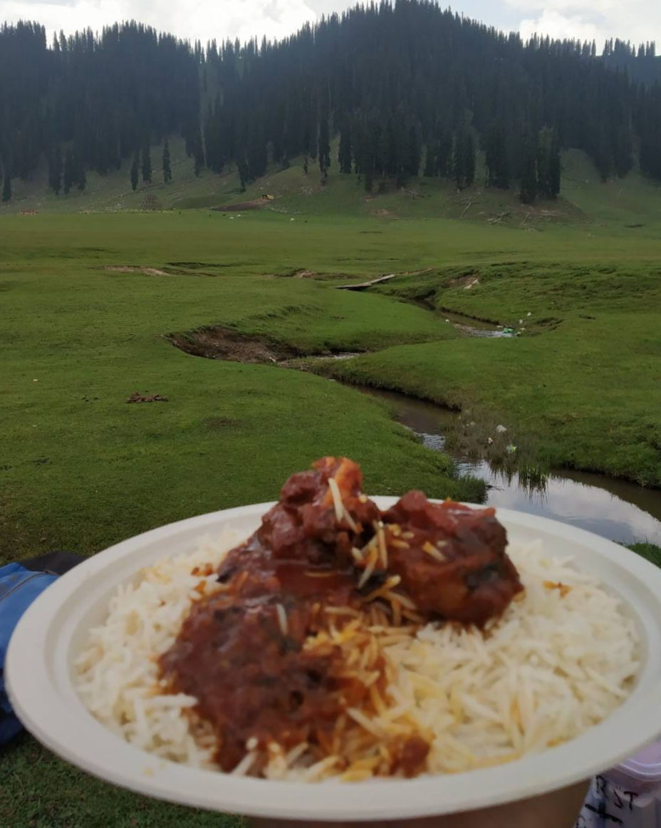
Somewhere in the middle of the meadow, near a stream that ran cold and clear over flat stones, we stopped. There had been a bet ,i would handle fuel. Zaid would bring food.
He produced Rogan josh - proper Kashmiri mutton curry in a container, the kind of smell that is entirely wrong for a high-altitude meadow and therefore entirely right. He had a trekking gas stove.
He lit it, warmed the curry, and we sat beside the stream and ate lunch with the meadow on every side and no other person visible in any direction.
The Rogan josh tasted the way food always tastes when you are outdoors and have earned it. Better than the same meal would taste in any restaurant.
Better than it had any right to taste at 10,000 feet beside a stream in the middle of a meadow in North Kashmir.We took photographs we made reels for Instagram, because we are both people who document what they see, and Bangus Valley deserved documentation. And then we put the phones away for a while and just sat with it.
Rogan josh heated on a trekking stove beside a Bangus stream, eaten with the meadow stretching to the horizon in every direction. There are restaurants in every city in India. There is only one of this
What Bangus Valley Actually Is - The Geography
Bangus Valley sits in Kupwara district, North Kashmir, at approximately 10,000 feet above sea level. The main valley - Bud Bangus covers an estimated 300 square kilometres.
The surrounding mountains form a natural boundary to the west, with Chowkibal and Karnah Guli to the north. The Mawri River flows through the valley.
For most of its modern history, Bangus remained off the tourist map partly due to the security situation in North Kashmir during the years of conflict, partly due to the absence of road infrastructure and accommodation. Both of these things have changed , the road has improved significantly. The security situation in this area is stable and the valley itself is exactly what it always was: an extraordinary stretch of high-altitude grassland that the nomadic communities have been using for centuries and that most tourists have never heard of.

No accommodation -and why that is the point
There are no hotels in Bangus Valley no guesthouses, no forest rest houses, nothing you can walk into and ask for a room. If you want to spend the night and you should, because the meadow at dawn is a different experience entirely from the meadow in the afternoon you bring a tent.
You carry everything you need. We did not have camping gear that day. It was a day trip, planned and executed as a day trip, and we left in the afternoon with the full knowledge that we were leaving something behind that we would have to come back for.
That feeling of knowing a place is bigger than the time you gave it is one of the better feelings a trip can produce.
Bangus Valley without an overnight is like arriving at Marwah Valley and leaving before the bowl reveals itself from above. You see it. You do not fully experience it. The meadow at sunrise — when the mist is still in the lower sections and the light comes over the eastern ridge — is worth carrying a tent for.
We arrange camping trips to Bangus Valley with full equipment — tent, sleeping bags, camp cook, transport. WhatsApp: wa.me/916006464123
The Return — Scorching Heat and a Stream Full of Kids
The descent back to where we had parked was in the afternoon, and the afternoon had become something else entirely from the cool morning we had started in.
The road down from the treeline was now scorching the kind of mountain heat that is unexpected at altitude and arrives with full conviction.
Somewhere on the descent we found a stream not a dramatic stream, not a famous waterfall, just a stream beside the road with clear cold water running over rocks and children from a nearby settlement taking a bath in it with the complete unselfconsciousness of people who live beside water and use it for what it is for.
We stopped ,the cold of the water after the afternoon heat was the kind of physical sensation that has no adequate description except to say that it was exactly right.
We sat in the stream for a while, said very little, and then got back in the car and drove to Srinagar with the windows down and the particular satisfaction of a day that had been unplanned and had worked out considerably better than most planned days.
How to Do in Bangus Valley — Everything You Need to Know
Details | What you need to know |
District | Kupwara, North Kashmir |
Distance from Srinagar | ~150 km — approximately 4 to 5 hours |
Three routes | 1. Mawar / Langate (the route we took) 2. Chowkibal 3. Rajwar, Handwara |
Altitude | ~10,000 feet above sea level |
The two valleys | Bud Bangus (Big Bangus) — main valley, ~300 sq km. Lokut Bangus (Small Bangus) — northeast of the main valley. |
Permit | No permit required for Indian nationals. |
Army post | You will pass an army post on the Mawar route. Show ID and continue. Routine checkpoint. |
Stay | No accommodation. Camping only carry your own gear or arrange through an operator. |
Vehicle | Road under construction beyond Kupwara on Mawar route. 4WD strongly recommended. |
Best season | June to September. Meadows at full green, nomadic communities present, all routes open. |
What to bring | Camping gear if staying overnight. Trekking gas stove if you want to cook on the meadow. Rogan josh optional but strongly recommended. |
Which route to take
Mawar via Langate - the route we took. Scenic, passes through Langate town, army post checkpoint on the way. Road improving but still rough beyond a point. 4WD essential.
Chowkibal route - the alternative entry from the north. Passes through Chowkibal town. Different perspective on the valley — worth considering if you want to see both approaches.
Rajwar, Handwara - the third option, coming from the Handwara side. Less commonly used. Suitable if you are approaching from the Handwara direction.
Take a proper 4WD regardless of which route you choose. The roads beyond the last town are mountain tracks, not highways. They improve every year but they are still mountain tracks. A vehicle that cannot handle uneven terrain will become the story of your trip rather than the meadow.
Frequently Asked Questions About Bangus Valley
Q: How far is Bangus Valley from Srinagar?
Approximately 150 km, taking 4 to 5 hours depending on route and road conditions. Add time for the walk-in from where the road ends, which can be 30 minutes to an hour depending on how far the road construction has progressed.
Q: Do I need a permit for Bangus Valley?
No permit required for Indian nationals. You will pass an army checkpoint on the Mawar route -standard ID check, take 5 minutes. Show your Aadhaar or equivalent and continue.
Q: Is there accommodation in Bangus Valley?
None. Camping only if you want to spend the night which we strongly recommend carry a tent and sleeping bag or book through an operator who brings everything. There are no guesthouses, no homestays, and no shortcuts to sleeping under the Bangus sky.
Q: What are Bud Bangus and Lokut Bangus?
Bud Bangus (Big Bangus) is the main valley approximately 300 square kilometres of high-altitude meadow that constitutes the primary Bangus experience. Lokut Bangus (Small Bangus) lies to the northeast, smaller and quieter, accessible by a walk from the main valley.
Q: What is the best time to visit Bangus Valley?
June to September. The meadows are at full green, the Gujjar and Bakarwal communities are present with their herds, and all three routes are accessible. Outside this window, the upper sections become snowbound and the experience changes significantly.
Q: Can I visit Bangus Valley as a day trip?
Yes we did it. But a day trip means leaving before the meadow shows you its best hours. Dawn in Bangus with mist in the lower sections and the first light on the grass is a completely different experience from the afternoon. One night minimum is the right approach if you want to understand what Bangus Valley actually is.
We are Tribesmen Travels, Srinagar. Bangus Valley is one of the offbeat destinations we cover alongside Warwan, Marwah, Gurez and Tosa Maidan. Every trip is arranged from the ground up — transport, camping, permits, local guidance. WhatsApp us and let's build your Kashmir trip.
Plan My Bangus Valley Trip — WhatsApp: wa.me/916006464123 | +91 600 6464 123


Comments