Mountain Peaks of Marwah Valley -The Fortress of the Western Himalayas
Updated: Sep 2
Most valleys in Kashmir have mountains on two sides. The road enters from one end, the river flows through the centre, and the peaks rise on the left and right flanks — a corridor, a linear space, a view in two directions.
This guide explains Marwah Valley’s 57 peaks — including geography, major summits like Mount Nun, and why this bowl-shaped valley is unique in Kashmir.
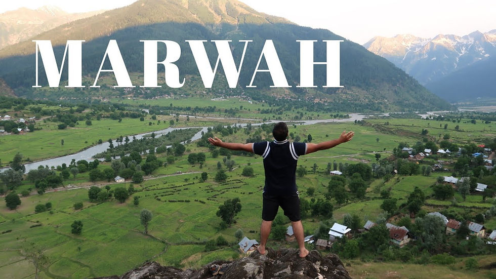
Marwah Valley has mountains on every side simultaneously.North ,south ,east .west. The bowl closes completely ,when you arrive at Marwah for the first time — especially if you arrive the right way.
From the Yourdoo ridge above, looking down into the full amphitheatre — you experience a geographical fact that is unique in Jammu and Kashmir: a valley entirely enclosed by its own peaks.
No open horizon ,no corridor, no exit that the eye can follow to flat ground. Just mountains, in every direction, rising from the valley floor to elevations that include the highest summit in the entire state.
Those mountains are 57 in number. Officially recorded. Source: PeakVisor topographic database.
No other accessible valley in Jammu & Kashmir — not Pahalgam, not Sonamarg, not Gurez — contains 57 recorded peaks. No other valley has Mount Nun in its skyline. No other valley closes on itself in every direction and forces the traveller to look up, rather than through. Marwah is not a corridor. It is a fortress. And it is open to anyone willing to cross Margan Top.

Quick Overview — Marwah Valley Peaks
Total peaks: 57 (PeakVisor database)
Highest peak: Mount Nun (23,410 ft)
Valley type: Bowl-shaped (fully enclosed)
Region: Kishtwar district, Jammu & Kashmir
Best for: Geography, trekking, mountaineering
Why the Bowl Changes Everything — A Geographical Argument
The word 'bowl' appears frequently in descriptions of Marwah Valley because no other word is as accurate. The technical term is a basin valley or cirque-derived bowl — a valley formation where surrounding peaks and ridgelines form a near-complete enclosure, rather than the typical linear corridor produced by river erosion in a single direction.
Marwah is the only formation of this type in Jammu and Kashmir. There are linear valleys everywhere in J&K — the Kashmir Valley itself is linear, the Lidder Valley at Pahalgam is linear, Gurez is linear. The bowl is not a matter of degree ,it is a different category of geographical experience.
The bowl geometry of Marwah Valley is the reason the peaks feel different here than anywhere else in Kashmir. In a linear valley, you see mountains. In Marwah, you are inside them. The peaks are not backdrop. They are walls. That is the distinction that every guest describes, in different words, within the first hour of arrival.
Looking to Explore Offbeat Kashmir?
Discover lesser-known valleys, villages and landscapes beyond the usual tourist circuit, with private transfers, carefully planned stays and personalised experiences.
57 Peaks — The Number That Sets Marwah Apart
According to PeakVisor, the globally recognised topographic database used by mountaineers, trekkers and geographers.
Marwah Valley contains 57 officially recorded mountain peaks. This is the highest concentration of named and recorded summits in any single accessible valley in Jammu and Kashmir.
To understand what 57 peaks means in context: the Great Himalayas, the Zanskar Range and the Pir Panjal Range all converge in or near the Marwah region.
The valley sits at the confluence of three major Himalayan systems — which is the geological reason for the density of summits, the extreme altitudes, and the bowl formation that results when ridgelines converge from multiple directions.
Most of these 57 peaks remain unnamed in common travel literature. Most have never been attempted by recreational climbers.
Many have never been documented in travel writing at all. What PeakVisor records is the topographic reality of this valley — a mountain concentration that rivals famous trekking regions in Nepal and the Karakoram, accessible by a road from Srinagar.
Why These Peaks Matter
The 57 peaks of Marwah are more than a geographical statistic. Together they create one of the most remarkable mountain landscapes in the western Himalayas.
These mountains support glaciers, rivers, wildlife habitats, alpine meadows and trekking routes that remain largely unexplored.
They also provide the foundation for nature tourism, mountaineering, wildlife photography and conservation-based livelihoods that could benefit local communities in the years ahead.
Region / Valley | Named peaks | Highest summit | Valley access |
Marwah Valley (Kishtwar) | 57 (source: PeakVisor) | 23,410 ft — Mount Nun | Road accessible via Margan Top. Bowl valley — peaks visible from floor in all directions. |
Pahalgam / Lidder Valley | ~12 named | ~17,799 ft — Kolahoi | Tourist highway. Views limited by linear valley geometry. |
Sonamarg / Sindh Valley | ~8 named | ~17,780 ft — Nichnai | Highly developed. Peak views as backdrop, not enclosure. |
Gurez Valley (Bandipora) | ~6 named | ~16,000 ft — Habba Khatoon area | ILP required. Linear valley. Kishanganga river dominant feature. |
The Four Named Peaks You Need to Know
A Landscape Built for Exploration
While Marwah remains largely unknown to mainstream travellers, landscapes like this attract a different kind of visitor.
Mountaineers, trekkers, wildlife photographers, researchers and nature enthusiasts are increasingly seeking destinations that offer wilderness, authenticity and ecological significance rather than commercial tourism infrastructure.
With 57 recorded peaks, access to Kishtwar High Altitude National Park, high-altitude lakes, glaciers and rare wildlife, Marwah possesses many of the characteristics that have made mountain regions in Nepal, Ladakh and Himachal Pradesh internationally recognised adventure destinations.
Among the 57, four peaks define the character of the Marwah skyline and represent the full vertical range of what this valley contains — from the highest summit in Jammu and Kashmir to the western wall peaks that give the fortress its most dramatic silhouette.
Mount Nun 23,410 ft / 7,135 m | The Highest Summit in Jammu & Kashmir
Mount Nun is the crown of Jammu and Kashmir. At 23,410 feet — 7,135 metres above sea level — it is the highest peak in the state, the highest point in the Zanskar Range, and one of the highest summits in the Indian Himalaya outside of Ladakh and the Karakoram.
It is part of the Nun-Kun massif — the twin-peaked giant that dominates the eastern horizon of the Marwah bowl. The base of Mount Nun falls within the Kishtwar district, on the Marwah side.
From the meadows near Mandikser, from the Shafa Glacier approach, and from Margan Top on the right morning, Nun is present — a summit that changes the scale of what you thought you understood about altitude.
The 1980s and early 1990s trekkers who made the classic route from Yourdoo through Methwan and Mundeksar toward Panikhar were walking through Nun's shadow.
The snow leopards that were camera-trapped in the Kishtwar National Park above Fariabad inhabit terrain at the base of this massif.
Everything extraordinary about Marwah Valley — the national park, the snow leopard, the Mandikser water body, the Shafa Glacier — exists because of the hydrology and geology that Nun and Kun created.
Z1 Peak 20,000 ft / 6,096 m | A 6,000-Metre Summit Inside the Bowl
Z1 Peak stands at 20,000 feet — at the threshold between high alpine and serious mountaineering altitude, the 6,000-metre class that separates the approach routes of serious trekkers from the technical routes of expeditions.
Z1 is accessible from within the Kishtwar National Park trekking corridors — specifically from the Kreshnala and Mandikser routes that run through the park.
Very few recreational climbers have attempted it. There is almost no published documentation about Z1 from a travel perspective.
It exists in the topographic record, in the PeakVisor database, and in the Marwah skyline — unnamed by most people who see it, but present, unmistakably, as one of the giants that forms the eastern wall of the bowl.
Ditch Peak 16,000 ft / 4,877 m | Named for the Geological Anomaly Below It
Ditch Peak sits above the Ditchnala zone — the same area as the salty stream that is unique in Jammu and Kashmir. The name is not metaphorical.
The peak takes its name from its position above the Ditch Nala , the same geological formation that produces the naturally saline stream that wildlife and nomadic herds have used as a mineral source for centuries.
The relationship between the peak and the stream below it is geological: the mineralogy of the summit feeds the watershed that produces the anomalous chemistry of the Ditchnala.
Standing at the salty stream and looking up at Ditch Peak, you are looking at the source of the thing that makes this location unique in J&K. The peak and the stream are the same geological story, told at different altitudes.

Dangerhell Peak 15,598 ft / 4,754 m | The Name Says Everything
15,598 feet. On the western wall of the Marwah bowl. The name — Dangerhell — was not invented for tourism. It was given by the people who attempted it or approached it, and it reflects what they found.
In a valley where Mount Nun is the highest summit and Z1 is the most technical approach, Dangerhell occupies a different register — the peak whose name alone communicates the character of its terrain.
It is not the tallest peak in the Marwah fortress. It is the one whose name stops you reading and makes you look up. That is a function that matters, and a USP that no other valley in Kashmir offers.
A valley with a peak called Dangerhell at 15,598 feet on its western wall, a peak at 20,000 feet on its eastern wall, and the highest summit in J&K on its southern horizon is not a valley that needs marketing language. It needs only to be described accurately.
The Fortress — What 57 Peaks Look Like From the Inside
A fortress in military architecture is defined by walls that are continuous, overlapping, and mutually supporting — each section of wall covering the approach angles that the adjacent section cannot.
The peaks of Marwah Valley function in exactly this way, which is why the word fortress is the most accurate available description of this geography.
The bowl is not a circle ,it is an irregular enclosure, formed by ridgelines that join and diverge at varying angles, creating a space where the mountains are always visible in multiple directions simultaneously and never in a single linear horizon.
Standing at the Domail confluence — where the Maru Sudar meets the Renie Nalla, the valley's most celebrated viewpoint — you can count ridgelines in six distinct directions.
The 57 peaks distributed across those ridgelines are not a list. They are a room with walls.
What this means for the traveller
The photographic implications alone are significant. Every angle from the valley floor produces a different mountain composition.
The light moves across these peaks in a sequence that changes every hour. For the trekker, the 57 peaks mean 57 potential objectives at varying levels of technical difficulty.
From the Margan Top plateau day walks that bring you within sight of the Nun massif, to the Kreshnala-Mandikser-Shafa Glacier route that takes you beneath Z1, to the national park circuits where Himalayan ibex move between the base camps of peaks that still have no common names.
Mandikser — Where the Peaks Meet the Water
The Mandikser is not a lake, it is a glacial river basin — a vast, open water body stretching approximately 7 to 8 kilometres in length and 1 to 1.5 kilometres in width at its broadest point, formed by meltwater descending from the peaks above including the Nun massif.
Natural sand islands and braided river channels cross its floor, shaped over centuries by the same glacial and geological forces that built the peaks enclosing it.
It is the geographical consequence of everything that makes Marwah extraordinary: the enclosure, the peak density, the altitude, the convergence of three Himalayan systems in a single basin.
Mandikser sits at the deepest point of the Kreshnala route in Kishtwar National Park. The route from Methwan through Kreshnala, Masabal, Rathakad meadow, and Mandikser is the most complete single route through the mountain geography of Marwah — from the last village through the snow leopard and ibex zones, past the milk-like stream at Rathakad, to the glacial basin beneath the highest peaks.
Mandikser is the destination that most Marwah Valley visitors never reach. It lies behind the Kishtwar National Park permit, the 1-2 days trek from Methwan, and the elevation gain that separates the valley floor from the high alpine. For those who make it, it is the geographical resolution of everything the bowl valley promises from below — the moment when the 57 peaks are not walls in the distance but peaks directly above you.

What the Fortress Protects — Marwah Valley Below the Peaks
The mountains of Marwah are extraordinary on their own terms. What they enclose makes the valley more than a mountaineering destination.
The 350-year-old cherry elm, Hanzal village
A single tree in Hanzal village that was growing during the reign of Emperor Aurangzeb. It has survived in the shelter of the bowl valley — protected by the same mountains that made Marwah inaccessible for long enough that a tree could reach this age without being cleared.
The fortress that the peaks provide is not only geographical. It is historical.
Mountains, People and Heritage
The mountains of Marwah do more than define the skyline. They have shaped the lives, traditions and livelihoods of the communities that live beneath them for generations.
The villages of Marwah, the seasonal movement of shepherds, the cultivation of Marwah Rajma, the high-altitude grazing grounds and the unique cultural identity of the valley all exist because of the environment created by these surrounding peaks.
In many mountain regions of the world, culture and landscape cannot be separated. Marwah is no different. The same mountains that shelter wildlife and glaciers have also protected traditions, agricultural practices and ways of life that remain largely unchanged from earlier generations.
The river islets — 13 to 17 natural formations
The Maru Sudar, braiding across the valley floor, creates 13 to 17 natural islets of varying sizes — sand, stone and grass formations that are the direct result of the bowl geometry. In a linear valley, the river has a single direction.
In the bowl, the water spreads, slows, and builds. The islets are what happens when a river reaches the end of a fortress.
Tata Pani — the hot spring beneath the peaks
The thermal activity that produces the Tata Pani hot spring — visited for centuries, famous across South Kashmir — is the same geology that produces the Ditch Peak anomalies above.
The mountain chemistry reaches the valley floor in the form of hot water. The fortress is not only visible. It is felt.
Marwah Rajma — food grown in a bowl
The organic red kidney beans of Marwah, renowned across India, grow at altitude in the shelter of the bowl.
The microclimate created by the enclosing peaks — the particular temperature, moisture and altitude combination that the bowl produces — is what gives Marwah Rajma its character.
The food is a product of the mountains. Everything in this valley is.
Domail confluence — where two rivers meet the fortress floor
At Domail, the Maru Sudar and the Renie Nalla join. The confluence is the valley's most celebrated viewpoint — the place where the full bowl geometry becomes legible, where the mountains in all directions simultaneously come into focus, and where visitors consistently run out of language for what they are seeing.
The Snow Leopard Fortress — Kishtwar National Park Above Marwah
Above the valley, behind Methwan village, the Kishtwar High Altitude National Park rises from 2,150 to 6,400 metres. It is J&K's only high-altitude national park, covering 2,191 square kilometres.
The same peaks that ring the Marwah bowl provide the terrain — bare rock, glacier, alpine meadow — that sustains the species that live there.
In 2021, camera trapping by Asgar Malik and the Wildlife Department confirmed snow leopard presence in the Fariabad region. Published in CATnews, the journal of the IUCN Cat Specialist Group.
The first confirmed sighting of a snow leopard from a protected area in Jammu and Kashmir. The location: the terrain beneath the peaks of the Marwah fortress.
The Himalayan ibex at Masabal, the brown bear at Rathakad, the possible lynx in the rocky terrain above Mandikser — all of these species inhabit the same peaks that form the walls of the bowl valley below.
The snow leopard follows the ibex. The ibex use the terrain of the peaks. The peaks are the habitat. The fortress is not just a landscape — it is an ecosystem.
The Wildlife Value of the Fortress
The peaks of Marwah are not simply mountains; they form the habitat of some of the most remarkable wildlife in the Himalayas.
The Snow Leopard, Himalayan Brown Bear, Musk Deer and Himalayan Ibex depend upon these high-altitude ecosystems for survival.
Recent evidence of Hangul presence and the possibility of the Himalayan Lynx further underline the conservation importance of this landscape.
For wildlife photographers, researchers and conservation travellers, such species represent far more than a checklist.
They are indicators of a healthy mountain ecosystem few destinations in India combine dramatic alpine scenery with the possibility of encountering or documenting such rare wildlife.
This gives Marwah a unique opportunity to emerge as a leading destination for responsible wildlife and conservation-based tourism.
Across the world, landscapes that support flagship species such as Snow Leopards become centres for conservation, research and specialised nature tourism. Marwah possesses the same potential.
The Explorers Who Came Before the Road
In the 1980s and early 1990s — before the motorable road, before Choharnag became a tourist attraction, before Marwah Valley appeared in any search result — international trekkers from India and Europe were already here.
They came for the peaks. The route from Yourdoo through Methwan and Mundeksar toward Panikhar in Kargil passed beneath the Nun massif and through terrain that very few professional mountaineers had documented.
The trekkers of that era understood what the topographic data confirms — that this valley contains a mountain concentration that rivals the Everest region in density, at altitudes accessible to serious trekkers, in a valley that had never been crowded.
The road came later. The tourism came later. What those early trekkers found — the peaks, the bowl, the silence, the scale — is still here. Unchanged. Now accessible to anyone with the willingness to cross Margan Top.
More Than 57 Peaks
Marwah's 57 peaks are impressive in their own right, but the true significance of this landscape lies in what those mountains support.
Beneath them flow the waters of the Maru Sudar, rise the forests and meadows of Kishtwar High Altitude National Park, and survive some of the Himalayas' most remarkable wildlife species.
Within this mountain basin lie alpine lakes such as Sarasnag and Choharnag, glacial landscapes such as Mandikser and Shafa Glacier, traditional villages, shepherd settlements and centuries-old cultural traditions.
Together, they form a complete Himalayan ecosystem where geography, wildlife, culture and conservation remain deeply interconnected.
From the villages of Marwah and the alpine waters of Sarasnag and Choharnag to the wilderness of Kishtwar High Altitude National Park and the shadow of Mount Nun, every part of this landscape is connected. Understanding Marwah means understanding the relationship between its mountains, people and wildlife.
This is why Marwah should not be viewed simply as a valley of peaks. It is one of the least explored mountain ecosystems in Jammu & Kashmir and perhaps one of the most remarkable landscapes in the western Himalayas.
The explorers who came in the 1980s are the reason we know what Marwah contains. The road that came later is the reason you can reach it. The 57 peaks are the reason you should.
Frequently Asked Questions
Q: How many peaks does Marwah Valley have?
57 officially recorded mountain peaks, according to the PeakVisor topographic database. This is the highest concentration of recorded summits in any single accessible valley in Jammu and Kashmir.
Q: What is the highest peak in Marwah Valley?
Mount Nun at 23,410 feet / 7,135 metres — the highest summit in Jammu and Kashmir and the highest peak in the Zanskar Range. It is part of the Nun-Kun massif, visible from the Margan Top on clear mornings.
Q: What is Z1 Peak?
Z1 Peak stands at 20,000 feet / 6,096 metres inside the Kishtwar National Park trekking zone above Marwah Valley. It is a 6,000-metre summit — serious mountaineering altitude — accessible via the Kreshnala and Mandikser routes. Very few recreational climbers have attempted it.
Q: What is Dangerhell Peak and why is it called that?
Dangerhell Peak stands at 15,598 feet on the western wall of the Marwah bowl. The name reflects the character of its terrain as assessed by those who first approached it.
In a valley that also contains Mount Nun and Z1, Dangerhell holds a different distinction — it is the peak whose name alone communicates the nature of the ground.
Q: Can I see the peaks from the valley floor?
Yes — and this is the defining experience of Marwah Valley. Because it is a bowl valley rather than a linear corridor, the peaks are visible in every direction simultaneously from the valley floor. Standing at Domail confluence or looking from the Yourdoo ridge, you see the full enclosure .
Q: What is Mandikser?
Mandikser is a glacial river basin inside the Kishtwar National Park, approximately 7 to 8 kilometres long and up to 1.5 kilometres wide, formed by meltwater from the peaks including the Nun massif.
It sits on the Kreshnala trekking route and is one of the most extraordinary high-altitude water features in the western Himalaya. Accessed via the Kishtwar National Park permit and a multi-day trek from Methwan.
Q: What is the source for the 57 peaks figure?
PeakVisor — the globally recognised topographic database used by mountaineers, trekkers and geographers worldwide.
The 57 figure represents officially recorded summits within the greater Marwah Valley region as catalogued in the PeakVisor database.
We are Tribesmen Travels, Srinagar. The fortress of the western Himalayas is our home territory. WhatsApp us and we will take you inside it.
Explore Marwah Valley — WhatsApp: wa.me/916006464123 | +91 600 6464 123


Comments