Mandeksar Travel Guide (2026): Kashmir's Largest High-Altitude Meadow, Mount Nun Base
Updated: Sep 2
Mandeksar or Mundeksar is a vast high-altitude meadow and wetland ecosystem in the upper reaches of Marwah Valley, Kishtwar district, Jammu & Kashmir.
Located towards Mount Nun—the highest peak in Jammu & Kashmir—it stretches nearly 7–9 kilometres in length and over a kilometre wide in places, making it one of the largest and least explored alpine landscapes in the western Himalayas.
This guide covers everything you need to know, including the trek route, itinerary, camping, wildlife, best time to visit, and practical travel tips.

Almost nobody has heard of Mandeksar that sentence, even in 2026, still holds true—and it says more about how well this Himalayan wilderness has remained hidden than about its extraordinary scale.
Most mountain destinations become famous for a single landmark: an alpine lake, a mountain pass, or a towering summit.
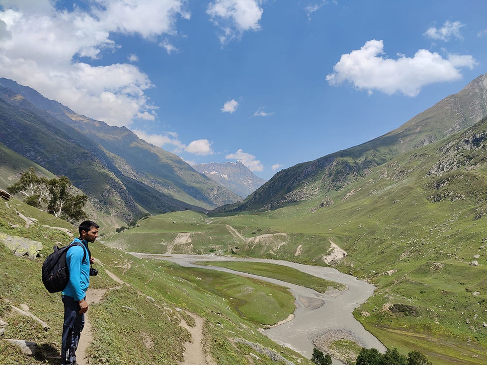
Mandeksar belongs to none of those categories. It is an entire landscape—a vast high-altitude wetland where glacier-fed streams descending from Mount Nun spread across endless meadows and marshes before converging into a single channel at a place called Kundi.
Here, the tranquil waters suddenly narrow, accelerating through a rocky gorge with a deafening roar that transforms the silence of the meadow into one of the most dramatic natural spectacles in Marwah Valley.
The sound reaches you before the gorge does. One moment you are walking through open alpine grasslands, surrounded by streams and wildflowers; the next, you are standing beside a torrent whose force seems to echo across the entire valley.
Very few trekkers have ventured into Mandeksar, and even fewer have documented it. This guide is an attempt to change that—not by making Mandeksar ordinary, but by providing those willing to venture into one of Kashmir's last great wilderness landscapes with the knowledge to experience it responsibly.
Quick Overview
Location | Upper Marwah Valley, Kishtwar District, Jammu & Kashmir |
Approximate Altitude | ~3,800–4,200 m (meadow and water body) |
Region | Kishtwar High Altitude National Park |
Nearest Village | Methwan (last major village before Mandeksar) |
Base Village | Marwah |
District | Kishtwar, Jammu & Kashmir |
Best Time to Visit | June to October |
Trek Difficulty | Moderate to Challenging |
Trek Duration | 5 days (Marwah return) |
Camping | Yes — open meadows, streams, no fixed camps |
Mobile Network | Unavailable beyond Renie Panchayat |
Guide Required | Strongly recommended — no marked trails |

Looking to Explore Offbeat Kashmir?
Discover lesser-known valleys, villages and landscapes beyond the usual tourist circuit, with private transfers, carefully planned stays and personalised experiences.
Where is Mandeksar?
Mandeksar lies in the upper reaches of Marwah Valley, in Kishtwar District, Jammu and Kashmir. The valley itself is one of the least-visited in the region — a long corridor running roughly parallel to Warwan Valley, separated from it by a high ridgeline, and accessible from Srinagar via the Margan Top pass or from Jammu through Kishtwar town.
Within Marwah, the road climbs through a sequence of villages — Marwah itself, then upward — before reaching the last drivable point at Tatapani.
Beyond here, the only way forward is on foot the trek follows the river corridor deeper into the mountains, through settlements that become progressively smaller and further apart, until the valley opens into something that no longer resembles a valley at all.
That opening is Mandeksar the site sits within the ecological boundary of the Kishtwar High Altitude National Park — one of India's least explored protected ecosystems, covering over 400 square kilometres of terrain that rises from temperate forest to permanent glacier. Mandeksar is, in effect, the wetland heart of that landscape.
→ See our full [MARWAH VALLEY GUIDE] for the complete background on the valley, villages, and approach routes.
Why Mandeksar is Unlike Anything Else in Kashmir
The Himalayas have alpine lakes by the hundred. Kashimir alone has several that appear on every offbeat trekking list — Vishansar, Krishansar, Gangabal, Choharnag. They are beautiful, and the comparison to Mandeksar is not meant to diminish them.
But Mandeksar is a different category of place. A lake has boundaries a shoreline a perimeter you can walk around, a single point of highest drama.
Mandeksar does not have any of those things. It has an extent the water begins where the meadow stops being simply meadow — gradually, without a clear announcement — and it spreads, fed by stream after stream coming down from the glaciers above Mount Nun.
Large marshy islands appear between the channels. The ground between water and grass is uncertain, soft underfoot, alive with the sounds of moving water from multiple directions at once.
You could walk alongside Mandeksar for hours and still not reach the far end of it. That scale — the simple fact of its scale — is what makes it genuinely singular.
And then comes Kundi,the transformation at Kundi is one of the more dramatic things this part of the Himalayas offers. The broad, spread-out water body — which has been moving slowly, quietly, across all those kilometres of meadow — suddenly finds itself with nowhere to go but through a narrow gap in the rock.
The compression is total the quiet disappears. The sound of the water becomes overwhelming in the way that very large, very fast water becomes overwhelming — not frightening, exactly, but commanding in a way that makes conversation impossible and makes standing there feel like the correct response.
At Kundi, the entire water body of Mandeksar — kilometres of meadow, marsh and stream — suddenly has nowhere to go but through a gap you could almost jump across. The sound is extraordinary.
The Mandeksar Trek — Route Guide
The standard route to Mandeksar is a five-day return from Marwah village, with two days of ascent, one day of exploration at Mandeksar, and two days of descent. The following is the complete route breakdown.
Srinagar (1,585 m) → Margan Top (3,700 m / 12,125 ft) → Marwah (~2,000 m) → Yourdoo → Tatapani (Road Ends) → Fariabad → Masibal → Watcher → Tegmarg → Rathikad → Mandeksar (~3,800–4,000 m) → Mount Nun Base (Optional)
Day | Route | Dist. | Time | Notes |
Day 1 | Marwah → Tatapani → Fariabad | ~12–15 km | 5–6 hrs | Pine and birch forest, river crossings, last tea possible at Tatapani |
Day 2 | Fariabad → Mandeksar | ~10–12 km | 5–6 hrs | Alpine transition, Masibal, Tegmarg meadows, arrival at Mandeksar |
Day 3 | Explore Mandeksar / Mount Nun viewpoints | Full day | — | Wetland exploration, Kundi narrows, glacier views, astrophotography |
Day 4 | Mandeksar → Fariabad | ~10–12 km | 4–5 hrs | Return descent |
Day 5 | Fariabad → Marwah | ~12–15 km | 4–5 hrs | Full return to base village |

Marwah to Fariabad via Tatapani
The road from Marwah ends at Tatapani — the last point a vehicle can reach. From here, the trek begins.
Tatapani means 'hot water' in Punjabi, a name given to places where natural springs emerge, and the presence of the name here suggests the area's geological character — the earth in this part of the Kishtwar mountains is restless in ways that periodically make themselves known at the surface.
The trail from Tatapani to Fariabad follows the river through a landscape that transitions from the relatively open lower valley into thickening pine and birch forest. The path is well-established from local use if not from trekking traffic, and a local guide will know its exact course through sections where it becomes less obvious.
Methwan is the last real settlement before Mandeksar. Camp here for the first night. The location is comfortable and well-watered, and the village offers a final opportunity for any provisioning before the push into the upper valley.
Fariabad to Mandeksar
This is the day the landscape transforms from Fariabad, the trail climbs through Masibal — a place where the valley narrows and the forest begins to thin — and then through Watcher, where the trees give way to the kind of open alpine terrain that signals serious altitude is being gained.
The settlement of Tegmarg sits in a broad meadow that gives a first hint of what Mandeksar will look like, except that Tegmarg is a preview and Mandeksar is the full version.
Rathikad comes shortly after — another waypoint that exists as a camp possibility for parties who started late from Fariabad or who are moving at a slower pace.
Beyond Rathikad, the gradient eases and the valley opens. The sound of water increases before the water itself becomes fully visible. And then Mandeksar — not dramatically, not with a sudden reveal, but gradually, in the way that large things present themselves: first in pieces, then in their entirety.
Camp at the edge of the meadow. The first night at Mandeksar, whatever else happens, tends to be the night that defines the trip.

Camping in Mandeksar
There are no fixed campsites at Mandeksar there are no designated pitching areas, no facilities, no other parties. You are camping in a high-altitude wilderness that does not know it is a camping destination, and the experience is shaped entirely by that fact.
The meadows offer multiple sites depending on how far you have walked on arrival and what view you want to wake up to.
The preference among people who have been here more than once tends to be a position slightly elevated above the main water body — high enough to see the wetland spread across the valley below, low enough that the sound of the streams is present without being overwhelming.

Night Skies
At this altitude, in a valley with no artificial light within sight in any direction, the night sky at Mandeksar is among the finest available in Jammu and Kashmir.
The Milky Way is visible as a structural feature rather than a faint smear. Astrophotography at Mandeksar, particularly in September and October when the atmosphere is at its most stable, produces results that are difficult to replicate anywhere closer to human settlement.
Silence
Silence here is relative — the streams are audible, the wind moves through the meadow, and occasional animal sounds emerge from the dark.
But the absence of human noise is total no engines, no voices, no signals. For travelers who spend most of their lives inside sound, this quality of quiet takes a day or two to fully register. By the second morning at Mandeksar, most people have stopped trying to fill it.
Wildflowers
In July and August, the meadows around Mandeksar carry a density of wildflowers that is characteristic of high-altitude ecosystems with abundant water.
Primulas, gentians, and various Himalayan alpine species appear across the marshy ground and drier meadow sections. The combination of wetland and open meadow creates a botanical diversity that landscape photographers specifically seek out — multiple distinct habitats within walking distance of each other.

Wildlife in and Around Mandeksar
Mandeksar sits within the Kishtwar High Altitude National Park — one of India's most biodiverse protected areas, though also one of the least studied.
The wildlife here is not the kind that presents itself for viewing. It is the kind that is aware of you before you are aware of it, and whose presence is more often inferred from tracks, sounds, and the reactions of the landscape than from direct sightings.
That said, the species list for this ecosystem is significant.

Species known to the Kishtwar High Altitude National Park ecosystem Himalayan Brown Bear — the species most commonly encountered in terms of signs and tracks at high altitude in the park. Snow Leopard — present in the upper terrain but a rare sighting by any measure; the greatest realistic expectation is pugmarks in snow. Himalayan Ibex — more regularly observed, particularly on open rocky terrain above the meadow zones. Musk Deer — shy and largely nocturnal; the scent-marking behaviour of males is sometimes the only indication of presence. Golden Eagle — visible soaring above the ridgelines on most clear days. Himalayan Marmot — commonly seen and heard on open slopes; their alarm calls are often the first signal that a predator is in the area. Numerous alpine birds — including Himalayan Snowcock, Snow Pigeon, and multiple raptor species. |
Sightings of large mammals cannot be guaranteed and should not form the primary reason for making this trek. The wildlife presence here is real but operates on the landscape's terms, not the visitor's schedule.
→ For a broader ecological picture, see our guide to the [KISHTWAR HIGH ALTITUDE NATIONAL PARK].

The Mount Nun Extension
Mount Nun stands at 7,135 metres — the highest peak in Jammu and Kashmir, a fact that is rarely as well-known as it should be.
From Mandeksar, experienced trekkers can continue upward toward the base of the mountain, entering terrain that begins to show the serious character of a genuine high-altitude environment: permanent snowfields, glacier approach, altitude that requires acclimatisation planning rather than simply fitness.
This is emphatically an extension for parties who have the technical preparedness, guide support, and planning to undertake it responsibly.
The terrain between Mandeksar and Mount Nun base is not difficult in the technical mountaineering sense on the standard approach — but it is high, remote, and without rescue infrastructure of any kind. Altitude sickness at this elevation, in this location, requires a plan that exists before the symptoms do.
For the majority of visitors, Mandeksar itself is the destination. The presence of Mount Nun on the skyline — visible clearly from the upper meadow on a clear day — is the experience. The extension requires a different category of commitment.
→ See our dedicated guide to [MOUNTAIN PEAKS OF MARWAH VALLEY] for detailed information on Mount Nun approach routes and requirements.
Best Time to Visit Mandeksar
The trekking season runs from June to October, and each month has a distinct character. The table below summarises the differences, but a few observations are worth adding.
Month | What to Expect |
June | Snow retreating from upper meadows. Streams high from melt. Wildflowers beginning on lower slopes. Cold nights. |
July | Peak wildflower season. Lush green. Long daylight. Best botanical photography. Occasional afternoon showers. |
August | Green at its most intense. Stable weather windows. Streams active. Excellent overall conditions. |
September | Weather stabilises further. Autumn colour begins. Mountain views exceptionally clear. Finest photography month. |
October | Golden meadows, silence, cold nights. Snow possible on higher terrain. A different and equally beautiful landscape. |
September is, by most measures, the month that Mandeksar performs best. The wildflower colour of summer has gone, but the clarity of the atmosphere in autumn — lower humidity, consistently sharp light, the first touches of gold on the higher slopes — produces a landscape that photographs differently from any other season and that feels, in person, like the valley has come into focus after a summer of beautiful blur.
October is for people who do not mind cold nights and the possibility of early snow on the upper terrain. The meadows are golden, the crowds (such as they are) have gone, and Mandeksar in late October has a quality of end-of-season solitude that is difficult to find in more accessible parts of Kashmir.
Practical Information
Fitness and Preparation
This is a moderate to challenging trek the daily distances are manageable for fit walkers, but the altitude gain — from around 2,000 metres at Marwah to over 4,000 metres at Mandeksar — requires proper acclimatisation.
The itinerary as structured allows for this, but travelers who arrive in Marwah directly from a low-altitude environment should consider spending an extra day in the valley before beginning the climb.
Guide
A local guide is strongly recommended ( Wajid wani from yourdoo is a registered wildlife guide There are no marked trails beyond Tatapani, and the terrain between Fariabad and Mandeksar has several sections where the route is not obvious.
A guide from Marwah (Yourdoo) village will know the exact path, the reliable water sources, the best camp positions, and — critically — the current conditions on the upper approach. We arrange guides through our local network; contact us before planning the trip.
Camping Equipment
There is no infrastructure at Mandeksar. Everything you sleep in, cook with, and shelter from weather with needs to be carried.
A four-season tent capable of handling wind and cold overnight temperatures is appropriate even in summer — the meadow is exposed and the altitude guarantees cold nights regardless of daytime warmth. A sleeping bag rated to minus 10 Celsius is the minimum sensible specification.
Food and Water
Carry all food supplies from Marwah. Water is available throughout the trek from streams, and at Mandeksar the water sources are abundant.
Permits
The Kishtwar High Altitude National Park may require entry permits for trekkers. Regulations in this area are subject to change, and we recommend confirming current requirements with the Marwah Ranger officer at yourdoo or through a registered tour operator before departure.
Leave No Trace
Mandeksar is pristine because very few people have been here. Everything carried in must be carried out. Fires should only be made where they are clearly safe and necessary — use a stove rather than a campfire wherever possible.
The wetland ecosystem is fragile and should not be walked through unnecessarily.
Photography at Mandeksar
Mandeksar is, for landscape photographers, the kind of location that justifies the planning required to reach it.
The combination of wetland, meadow, glacier, and sky creates a visual complexity that is rare even in the Himalayas — and the low visitor numbers mean you can position yourself for a shot without managing other people in the frame.
• Sunrise: The eastern ridgeline catches the first light before the meadow, creating a layered effect — dark wetland in foreground, lit peaks above. Position yourself on the western edge of the meadow before first light.
• Sunset: The western slopes above Mandeksar hold colour long after the valley floor is in shadow. A high vantage point above the main water body gives the best angle.
• Wildflowers: July and August. Macro work in the marshy sections reveals species rarely photographed because so few photographers have been here.
• Kundi: The compression of the water body into the narrows is a strong compositional subject — use a long exposure to show the water movement against the static rock.
• Astrophotography: September and October, after midnight. The Milky Way core is visible well into autumn at this latitude and altitude. Zero light pollution within the visible horizon in any direction.
• Drones: Subject to current regulations within the Kishtwar High Altitude National Park. Confirm permissions before bringing equipment.
Nearby Places — Extend Your Marwah Journey
Mandeksar sits within a region that rewards staying longer. The places listed below are all accessible in connection with a Mandeksar expedition and represent some of the least-visited terrain in Jammu and Kashmir.
• Marwah Valley: The base for any Mandeksar trip — a bowl valley of exceptional beauty with a character entirely distinct from mainstream Kashmir. [MARWAH VALLEY GUIDE]
• Warwan Valley: The adjacent valley, accessible via a high ridge crossing. One of Kashmir's most remote inhabited valleys. [WARWAN VALLEY GUIDE]
• Famber Valley: A short side valley off Marwah, visited by almost nobody and offering meadow landscapes of a similar quality to Mandeksar at lower altitude. [FAMBER VALLEY GUIDE]
• Choharnag Lakes: A cluster of high-altitude lakes in the broader Kishtwar region, reached by a separate approach. A contrast to Mandeksar's wetland character. [CHOHARNAG LAKES GUIDE]
• Margan Top: The mountain pass that separates south Kashmir from Warwan and Marwah — dramatic in both directions and worth a dedicated stop. [MARGAN TOP GUIDE]
Frequently Asked Questions
What is Mandeksar?
Mandeksar is a vast high-altitude wetland ecosystem in the upper reaches of Marwah Valley, Kishtwar District, Jammu and Kashmir.
Streams descending from Mount Nun, J&K's highest peak, feed a water body stretching nearly 7 to 9 kilometres in length and over a kilometre wide in places — making it one of the largest high-altitude meadow-wetland systems in the western Himalayas.
How do I reach Mandeksar?
The standard approach is a 5-day return trek from Marwah village. The road from Marwah ends at Tatapani, after which the trail continues on foot through Fariabad to Mandeksar. A local guide is strongly recommended as the trails are unmarked beyond Tatapani.
What is the best time to visit Mandeksar?
June to October is the trekking season. September offers the finest combination of clear skies, stable weather, and autumn colour — and is the most recommended month for photography and the overall quality of the experience.
How difficult is the Mandeksar trek?
The trek is rated moderate to challenging. Daily distances are not extreme, but the altitude gain from approximately 2,000 metres at Marwah to over 4,000 metres at Mandeksar requires proper acclimatisation and a reasonable baseline fitness level.
Is a guide required for Mandeksar?
Yes — strongly recommended. There are no marked trails beyond Tatapani, and the route through the upper valley to Mandeksar requires local knowledge of the terrain and conditions. Tribesmen arranges local guides from Marwah Yourdoo village.
What wildlife might I see in Mandeksar?
The Kishtwar High Altitude National Park ecosystem around Mandeksar supports Himalayan Brown Bear, Snow Leopard (rare), Himalayan Ibex, Musk Deer, Golden Eagle, Himalayan Marmot, and numerous alpine bird species. Sightings of large mammals are not guaranteed and depend on season and conditions.
Can I camp at Mandeksar?
Yes. The meadows at Mandeksar offer exceptional open camping on flat, well-watered ground. There are no fixed campsites or facilities — all equipment must be carried in. Night skies here are among the finest in Kashmir due to complete absence of light pollution.
Can I trek from Mandeksar to Mount Nun base?
Experienced trekkers with proper guide support and technical preparedness can continue toward Mount Nun base from Mandeksar. This is an extension requiring serious planning and is not recommended without prior high-altitude trekking experience and local guidance.
Can Mandeksar be combined with Warwan Valley?
Yes, and this is one of the most complete offbeat journeys available in this part of Kashmir. The two valleys are separated by a high ridge, and an experienced local guide can arrange the crossing. Allow additional days for this route.
Are permits required for Mandeksar?
The site falls within the Kishtwar High Altitude National Park, and entry permits may be required. Regulations change; we recommend confirming current requirements with the Kishtwar Forest Department or through a registered operator before departure.
The Final Word
There are places in the Himalayas that are beautiful in the way that famous places are beautiful — photographed, understood, their drama already processed into expectation before you arrive. Mandeksar is not one of those places.
It is a place where the scale of things genuinely surprises you. Where the question of what the cave system contains or what the water body conceals at its far end or what crosses the meadow in the hours before dawn remains genuinely open.
Where the night sky is not a background feature but the entire point of the hours between dark and light.
Kashmir still contains landscapes of this quality. Marwah Valley is one of them. Mandeksar is its highest expression — an enormous high-altitude wilderness where glacier-fed water, ancient meadow, the highest mountain in the state, and a silence that has not yet learned what silence is for come together in a way that very few places in the world still can.
Go when you are ready. Bring less than you think you need. Stay longer than you planned.
Trek Mandeksar with Tribesmen We organise private and small-group expeditions to Mandeksar, Marwah Valley and the wider Marwah region — with local guides, full equipment support, and no fixed-group timelines. WhatsApp / Call: +91 600 6464 123 support@tribesmen.org | www.tribesmen.org Kashmir-based · J&K Tourism Licensed · Marwah Valley specialists |


Comments