Peer Ki Gali: Mughal Road, Sarai's & Travel Guide
Updated: Sep 2
The Road the Mughals Took
Long before the Srinagar–Jammu National Highway became Kashmir's principal gateway, emperors, armies, merchants, and caravans crossed the Pir Panjal through a mountain pass known today as Peer Ki Gali.
Every summer, this route carried the Mughal court towards its beloved capital of Kashmir, leaving behind a remarkable legacy of caravan serais, mountain shrines, and one of the most spectacular landscapes in the western Himalayas.
Today, the same road offers travellers an opportunity to experience history and nature on a journey that remains surprisingly overlooked.
Unlike the Srinagar–Gulmarg or Srinagar–Pahalgam routes — both of them well-worn and heavily touristed — the Mughal Road still feels raw.
The journey from Shopian to Peer Ki Gali and beyond towards Rajouri carries a quality that is increasingly rare in Kashmir's more popular tourist corridors: the sense that not very many people have been here before you.

Peer Ki Gali at a Glance
Location: Pir Panjal Range, Shopian District, Kashmir
Elevation: Approximately 3,490 metres (11,450 ft) above sea level
Distance from Srinagar: Approximately 90–95 km (2.5–3 hours)
Road: Historic Mughal Road connecting Shopian with Rajouri
Historical Significance: One of the principal routes used by the Mughal emperors while travelling to their summer capital, Kashmir
Major Attractions: Peer Ki Gali Pass, Mughal Sarai, Allahabad Sarai, Shrine of Baba Ahmed Karim, Pir Panjal landscapes
Best Time to Visit: Late May to September
Ideal Trip Duration: Full-day excursion or part of a 2-day itinerary with Aharbal, Daksum, or Pahalgam
Nearest Town: Shopian (approximately 35 km)
Perfect For: History enthusiasts, photographers, nature lovers, road-trip enthusiasts, and offbeat Kashmir travellers
Facilities: Limited food and accommodation; carry packed meals, drinking water, and warm clothing
Road Status: Usually open from late May until autumn, subject to weather and snowfall
Looking to Explore Offbeat Kashmir?
Discover lesser-known valleys, villages and landscapes beyond the usual tourist circuit, with private transfers, carefully planned stays and personalised experiences.
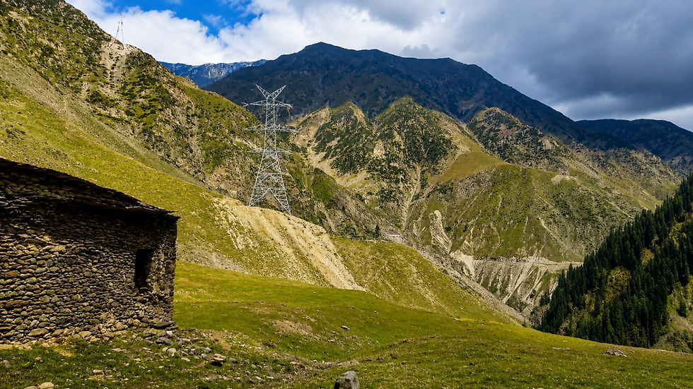
From Shopian's Apple Orchards to the Pir Panjal Mountains
The real journey begins after Shopian. During harvest season, the road winds through endless apple orchards that have earned the district its reputation as the Apple Bowl of Kashmir.
Gradually, the orchards begin to disappear, replaced by dense conifer forests, mountain streams, and sweeping alpine slopes. Every kilometre feels like a transition—from cultivated valleys to untamed mountains—until the Pir Panjal finally unfolds before you in all its grandeur.
What is Peer Ki Gali?
Elevation, Location and Geography
Peer Ki Gali sits at an elevation of approximately 3,490 metres above sea level, making it one of the higher accessible passes in the Kashmir Himalaya.
It occupies a strategic position in the Pir Panjal Range, serving as the principal crossing point on the Mughal Road — the historic highway connecting the Kashmir Valley with the Rajouri and Poonch districts of Jammu through the mountains.
The pass lies on the Shopian–Rajouri road, which follows the alignment of the original Mughal route with considerable fidelity. To the north lies the Kashmir Valley; to the south, the middle hills and eventually the plains of Jammu.
The Pir Panjal acts as the climatic and geographical divide between these two worlds, and Peer Ki Gali is the point at which that divide is most dramatically felt.
In terms of modern road connectivity, the Mughal Road serves as an important alternative link between the Kashmir Valley and Jammu, bypassing the National Highway through Banihal and providing a seasonal connection to communities in Rajouri and Poonch that would otherwise rely on much longer routes.
The History of Peer Ki Gali and the Mughal Road
The Mughal Road is one of the most historically significant mountain routes in the Indian subcontinent. At the height of Mughal power, when the emperors retreated from the heat of the plains to spend their summers in Kashmir .
The route across the Pir Panjal was the preferred path — shorter than the Banihal route under certain conditions, and passing through landscapes that the Mughals, with their documented love of gardens and natural scenery, found deeply appealing.
Historical accounts confirm that Emperor Akbar used the Pir Panjal route during his Kashmir journeys. The Mughal emperor Jahangir, whose memoirs contain some of the most evocative descriptions of Kashmir's landscape ever written, also crossed these mountains.
The royal retinue — which might include thousands of attendants, soldiers, servants, animals, and equipment — required a significant logistical infrastructure to move safely through difficult mountain terrain over multiple days.
The answer to that logistical challenge was the caravan sarai: a network of resting places constructed at regular intervals along the route, providing shelter, water, and basic facilities for travellers. Two of these historic serais — the Mughal Sarai and the Allahabad Sarai .
Allahabad Sarai
The Allahabad Sarai lies a little below the present road, positioned beside a mountain stream in a manner typical of Mughal sarai placement — water access was a primary consideration in siting these structures. It is in a neglected and dilapidated condition, and that neglect is perhaps the most significant failure of heritage stewardship in this part of Kashmir.
What remains is enough to understand what once stood here. The scale of the structure, even in its present state, communicates the seriousness with which the Mughals approached the logistics of mountain travel.
This was not a modest way station — it was a substantial resting place designed to receive an imperial retinue. The stonework, the general layout, and the placement beside running water all reflect a sophisticated understanding of what mountain travellers needed.
The Allahabad Sarai deserves conservation attention — not as a museum piece, but as a living piece of the Mughal Road's documented history.

Mughal Sarai
The Mughal Sarai is in considerably better condition, and it is the one that most visitors on the Mughal Road have any realistic chance of exploring.
It sits only five to ten minutes downhill from the main road — a short, easy walk from a parking area beside the highway. There is nothing physically demanding about the access, which means the decision to stop here is purely a matter of intention.
The architecture is immediately impressive. Stone construction, Islamic arches, individual chambers arranged around a central space — the structure speaks a clear Mughal architectural language, translated into the materials available at this altitude.
The surviving elements give a strong sense of the original scale and layout, even where walls have partially collapsed or surfaces have weathered. The mountain backdrop — Pir Panjal rising in multiple directions — makes the Mughal Sarai one of the more striking photography locations on the entire Mughal Road.
A mountain stream runs nearby, its water eventually joining the Jhelum River system downstream. In summer, wildflowers appear in the grass around the sarai. In early season, snow lingers on the surrounding slopes.
Photography enthusiasts will find the combination of historic stone architecture, Islamic geometric details, mountain light, and alpine setting unusually productive. Early morning, when mist moves through the valley below the pass and the light falls at low angles across the stonework, is the most rewarding time.

Why is it Called Peer Ki Gali?
The name translates directly from Kashmiri and Urdu: Peer means a Muslim saint or spiritual elder; Gali means a pass or narrow mountain gateway. The pass derives its name from Baba Ahmed Karim or Sheikh Ahmed Karim, a revered figure whose shrine still stands near the summit.
Local tradition holds that Baba Ahmed Karim was a saint who lived and meditated in this high mountain setting, and whose presence gave the pass its spiritual character.
The shrine is maintained and visited by local communities, particularly those from the surrounding villages and by travellers passing through. It occupies a position at the pass that has made it a landmark for generations of mountain travellers.
The Pir Panjal Landscape: What You Will Actually See
The Pir Panjal Range is not the highest mountain system in Kashmir — that distinction belongs to the Great Himalayan Range further north — but it is arguably the most varied and, at the right time of year, the most beautiful.
The ecosystem at and around Peer Ki Gali spans multiple vegetation zones compressed into a relatively short elevation gain, which means that a single journey from Shopian to the pass moves through several distinct landscapes in under two hours.
The lower sections of the climb are forested. Deodar cedar and blue pine dominate at mid-elevations, giving way to fir and birch as the road climbs higher. In summer, these forests are genuinely dense — the kind of mountain forest where the canopy closes overhead and the road runs in cool shadow even at midday.

Shepherds and their flocks are a consistent presence throughout the summer season. The high pastures around Peer Ki Gali serve as summer grazing grounds for Gujjar and Bakarwal communities who bring their cattle, horses, and sheep up from the valleys in late spring and descend again in autumn.
Clear mornings can give way to afternoon cloud and rain within a matter of hours. Mist moves through the Pir Panjal quickly and can reduce visibility significantly. Temperatures at the pass are considerably lower than in Srinagar or Shopian even in midsummer, and the wind at the ridgeline can be sharp layers are not optional.
Planning Your Visit: Two Practical Itineraries
Option 1: Peer Ki Gali and Aharbal in One Day
→ Depart Srinagar by 7:00 AM
→ Drive through Shopian (approximately 60 km, 1.5 hours)
→ Climb to Peer Ki Gali — allow 45–60 minutes from Shopian
→ Visit Mughal Sarai (park on highway, 10-minute walk down and back)
→ Visit Allahabad Sarai if conditions allow
→ Photography and picnic at the pass — allow 1.5–2 hours
→ Descend towards Aharbal Waterfall (approximately 1 hour from the pass)
→ Afternoon at Aharbal
→ Night stay at Aharbal guesthouse
This itinerary works well for those who want a focused exploration of the Mughal Road heritage sites combined with one of Kashmir's most impressive waterfalls. Aharbal — where the Vishav River drops over a wide basalt lip in a fall that reaches close to 25 metres — is spectacular after the rains and easily combined with a Peer Ki Gali visit. For our detailed coverage, see our Aharbal guide.
Option 2: The Mughal Road Extended Circuit
→ Depart Srinagar by 6:30 AM
→ Peer Ki Gali via Shopian
→ Aharbal Waterfall
→ Continue towards Daksum for night stay
OR
→ Continue from Aharbal towards Pahalgam via the hill road
→ Night stay in Pahalgam
The extended circuit suits travellers who want to spend two days in the southern Kashmir highlands, linking the Mughal Road heritage with the forests of Daksum or the Lidder Valley at Pahalgam.
The Daksum option in particular opens up further exploration towards Sinthan Top and the route into Kishtwar — a journey that connects naturally with our guides to Marwah Valley and Warwan Valley for those considering a deeper traverse of the Chenab region.
Distances to keep in mind: Srinagar to Peer Ki Gali is approximately 90–95 kilometres depending on the precise route. Peer Ki Gali to Aharbal is around 35–40 kilometres. Aharbal to Daksum is a further 60 kilometres on mountain roads.
Food and Supplies: What to Bring
The Mughal Road between Shopian and the pass is not a tourist highway in any developed sense. There are no restaurants at Peer Ki Gali, no cafés at the Mughal Sarai, and no reliable supply of drinking water beyond the mountain streams. The food stalls that appear at some popular Kashmiri viewpoints are largely absent here.
This is not a problem — it is a quality. The pass retains its unhurried character precisely because it has not been developed for mass tourism. But it does require preparation.
• Carry a packed meal — a proper lunch, not just snacks
• Bring at least two litres of drinking water per person
• Pack warm clothing regardless of the Srinagar weather forecast — the pass is significantly colder
• Carry a rain layer — afternoon rain is common in summer
• Bring a first aid kit if you are planning any off-road walking
A picnic at the pass, with the Pir Panjal as backdrop and the Mughal Sarai within walking distance, is one of the more memorable meals you can have in Kashmir. Use the mountain streams for washing hands, not for drinking — water quality at any altitude should be treated with appropriate caution.

Best Time to Visit Peer Ki Gali
Late May
The road typically opens in late May, though the exact date varies with snowfall. In a heavy snow year, the pass may not be reliably accessible until early June.
When it does open, the upper meadows often still carry significant snow on north-facing slopes, which creates a dramatic contrast with the first wildflowers on the south-facing aspects.
June
June is the transition month. Snow disappears progressively from the pass area. The meadows come into full colour. Shepherd communities arrive with their livestock. The days are long and the weather is usually settled in the first half of the month before the monsoon influence begins to be felt.
July and August
These are the peak months for landscape photography and general visiting. The alpine meadows are at their most vivid, the wildflowers at maximum variety, and the shepherds and their animals give the landscape a human and pastoral quality that is genuinely beautiful.
September
September is arguably the most underrated month for the Mughal Road. The monsoon influence withdraws, skies clarify, and the light takes on the particular quality of high-altitude autumn. The meadows begin to turn — amber and ochre replacing the summer green — and the surrounding peaks become sharper in the cleaner air.
Photography at Peer Ki Gali
The Mughal road between Shopian and Peer Ki Gali offers several distinct types of photographic opportunity, and they reward different approaches.
The Mughal Sarai is best photographed in morning light, when the sun comes from the east and illuminates the stone façade directly.
The combination of Islamic arches, weathered stone, mountain backdrop, and nearby stream gives the location a quality that is unusual in the Kashmir landscape — old architecture in a high mountain setting, without any modern development in the immediate vicinity.
The pass itself is a landscape photography location. Meadow foregrounds, Pir Panjal ridgelines in the middle distance, sky above — the classic mountain composition is available in multiple directions.
The shepherds and their flocks offer portrait and documentary opportunities for those who approach respectfully and ask before photographing.
The Bakarwal and Gujjar communities are accustomed to visitors on the Mughal Road, but a genuine interaction — even a brief one — will always produce better images than shooting from a distance.

The Road Worth Taking
Peer Ki Gali does not offer easy satisfactions. There is no cable car, no manicured garden, no queue for a selfie spot.
What it offers instead is something that Kashmir's more accessible destinations have largely traded away in exchange for infrastructure: a genuine sense of place, an unmediated encounter with a landscape that has been significant for centuries, and the particular quality of silence that belongs to high mountain passes in the early morning.
The Mughal emperors who crossed these mountains were making a journey of considerable difficulty and some danger, and they did it because Kashmir was worth it.
The Pir Panjal ecosystem around the pass is one of the most ecologically rich and visually compelling mountain landscapes in the western Himalayas. The wildflowers, the shepherds, the alpine meadows, the streams running down towards the Jhelum — this is Kashmir in a register that the Pahalgam road and the Gulmarg gondola do not offer.
For travellers willing to start early, carry their own food and water, and approach the journey with genuine curiosity rather than a checklist of highlights, Peer Ki Gali remains one of the most rewarding day trips available from Srinagar. Combined with Aharbal, or extended into the two-day circuit through Daksum, it offers a window into a Kashmir that moves at its own pace and on its own terms.
For further exploration beyond Peer Ki Gali, our guides to Daksum, Margan Top, Marwah Valley, Warwan Valley, and Kashmir Beyond Pahalgam cover the routes and destinations that connect naturally with the Mughal Road journey.
Frequently Asked Questions
Where is Peer Ki Gali located?
Peer Ki Gali is a high mountain pass in the Pir Panjal Range of Kashmir, located on the Mughal Road connecting Shopian in the Kashmir Valley with Rajouri and Poonch in the Jammu division. It sits at an elevation of approximately 3,490 metres above sea level.
How far is Peer Ki Gali from Srinagar?
Peer Ki Gali is approximately 90–95 kilometres from Srinagar by road, passing through Shopian. Under normal road conditions, the journey takes approximately two to two and a half hours. Traffic through Shopian and the condition of the upper road sections can affect travel time.
What is the best time to visit Peer Ki Gali?
Late May through September offers the most reliable access and the best landscape conditions. June through August are peak months for wildflowers and pastoral scenery. September is excellent for photography with cleaner autumn light and less cloud cover. The road is typically closed from November to late May due to snowfall at the pass.
What is the Mughal Sarai near Peer Ki Gali?
The Mughal Sarai is a historic caravan rest house built during the Mughal period to serve travellers on the mountain route between the Kashmir Valley and the plains of Jammu. It is located a short walk below the main Mughal Road, approximately five to ten minutes from the highway parking area, and is in relatively good condition compared to other historic structures in the area.
What is the Allahabad Sarai?
The Allahabad Sarai is a second historic caravan rest house situated a little below the present road, beside a mountain stream. It is older and in a more dilapidated condition than the Mughal Sarai. The structure holds significant historical importance and deserves conservation attention, though it currently remains largely unprotected and unrestored.
Why is the pass called Peer Ki Gali?
The name derives from Baba Ahmed Karim, a revered saint whose shrine stands near the summit of the pass. Peer is the Urdu and Kashmiri term for a Muslim saint or spiritual elder; Gali refers to a mountain pass or narrow defile. The shrine is still maintained and visited by local communities.
Is the Mughal Road safe to drive?
The Mughal Road is generally safe during the open season (late May to October) under normal weather conditions. The road is narrow in sections and passes through remote terrain where mobile connectivity is limited. Travellers should check road conditions before departure, particularly after heavy rain. Starting early in the day is recommended to avoid afternoon weather changes at the pass.
Are there restaurants or food facilities at Peer Ki Gali?
There are no restaurants, cafés, or reliable food stalls at or near Peer Ki Gali. Travellers should carry packed meals, drinking water, and warm clothing. The nearest town with basic food facilities is Shopian, approximately one hour below the pass.
Can Peer Ki Gali be visited as a day trip from Srinagar?
Yes. A day trip from Srinagar to Peer Ki Gali and back, including time at the Mughal Sarai and the pass itself, is comfortable if you depart by 7:00 AM. Combining with Aharbal Waterfall on the same day is also possible, ending with a night stay at Aharbal rather than returning to Srinagar.
What other destinations can be combined with a Peer Ki Gali visit?
Aharbal Waterfall is the most natural combination — it is approximately 35–40 kilometres from the pass and makes an excellent afternoon stop. From Aharbal, routes continue towards Daksum, Sinthan Top, and further into the Kishtwar highlands towards Marwah Valley and Warwan Valley. Pahalgam is also accessible via the hill road from Aharbal for those planning a two-day circuit.
Deep Read for Tribesmen Travels
Plan a Peer Ki Gali with Tribesmen
We arrange private day trips and offbeat itineraries to Yusmarg, Tosa Maidan, Marwah ,Warwan , Gurez etc — with a driver who knows these roads.
WhatsApp / Call: +91 600 6464 123
Kashmir-based · J&K Tourism Licensed · Offbeat Kashmir specialists


Comments